Passive and Low Energy Architecture conference:
This research, presented at the Passive and Low Energy Architecture (PLEA) conference, investigates whether the passive environmental performance embedded in historical vernacular urban morphologies can be systematically abstracted and reapplied to contemporary urban development. The central hypothesis is that pre-industrial settlements in climatically similar regions — built before mechanical heating and cooling were available, and therefore evolved to achieve thermal comfort through spatial and formal means alone — encode design intelligence that remains directly applicable to the challenge of reducing energy demand and improving outdoor thermal comfort in modern cities.
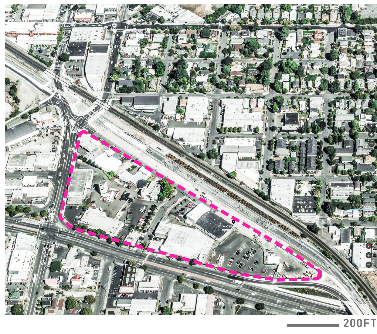
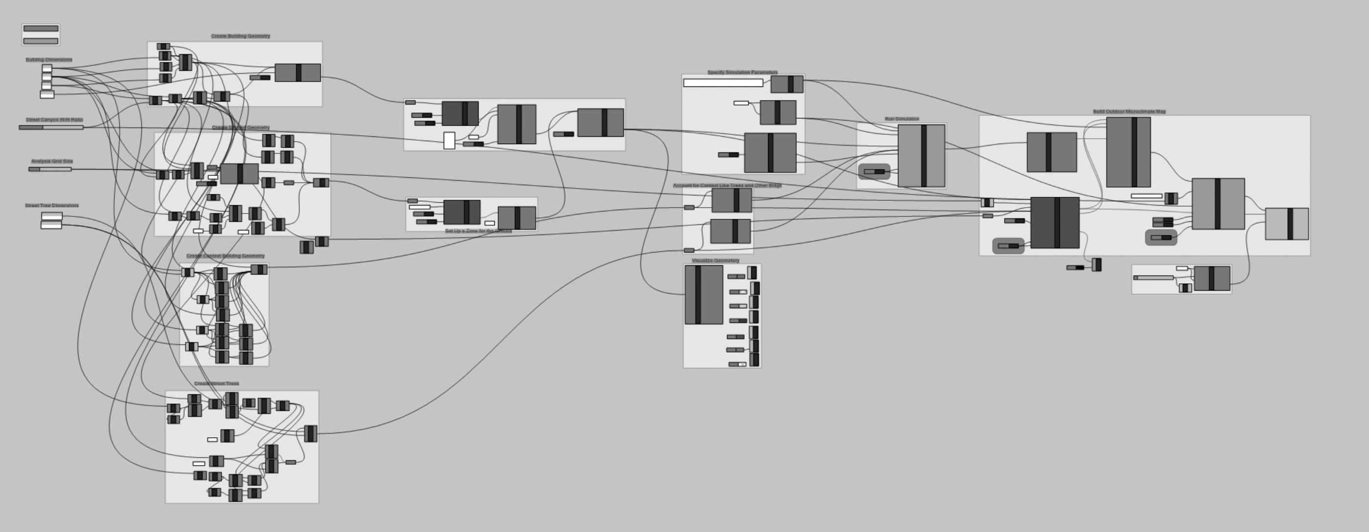
From an initial survey of 20 vernacular case studies across multiple climate zones, 5 were identified as climatically analogous to the project's target site — the Clinton Triangle in Portland, Oregon, which falls within the Csb ("cool-dry summer") classification under the Köppen-Geiger climate classification scheme: the Casbah of Algiers, the Greek island of Hydra, and the Italian towns of Alberobello, Anticoli Corrado, and Positano. Three underlying design principles were abstracted from these precedents as the primary experimental variables: (1) the street condition — the proportion, orientation, and enclosure ratio of the primary pedestrian circulation network; (2) the void condition — the deliberate removal of building volumes from the urban grid to create shaded plazas and air circulation paths; and (3) volumetric roughness — the rotation and asymmetric articulation of building masses to disrupt laminar airflow, reduce wind-induced discomfort, and vary solar exposure across façade surfaces. Each principle was applied iteratively to a baseline urban grid calibrated to the Portland site, and the resulting morphological variants were evaluated for outdoor thermal performance through UTCI (Universal Thermal Climate Index) analysis using Grasshopper Ladybug and CFD (Computational Fluid Dynamics) simulation using ANSYS Fluent.
Contributions
Summary:
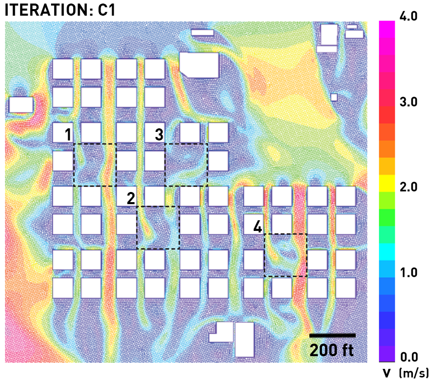
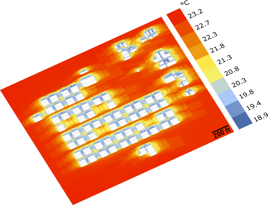
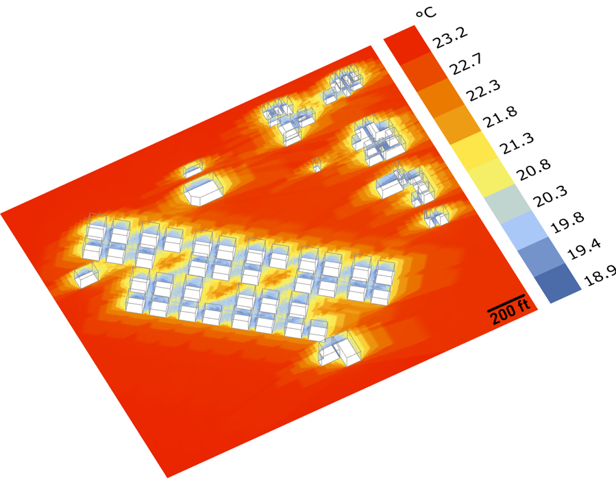
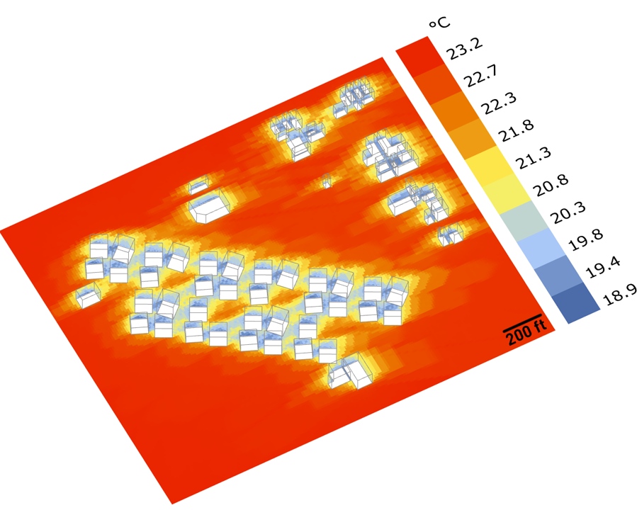
I performed UTCI analysis of the city grid after applying each design principle in an iterative manner. By focusing on the two most important aspects of UTCI -sky heat exchange and wind speed within the city grid, I narrowed down the simulations to sky heat transfer benchmarking with Grasshopper Ladybug's radiation analysis suite (Fig. 3), and wind speed in the various geometries through ANSYS CFD analysis (Fig. 5). Using climatic data for Portland and the temperature and wind speed values at important locations within the development (plazas and key streets), I translated the simulated values into UTCI. I also translated the wind speed values into a unitless vorticity magnitude, which was compared against the UTCI to determine the wind effects on average UTCI (Table 1). Findings showed that the iterative operations on the urban morphology decresed the average UTCI values and placed it within the "no heat stress" category, when compared to the initial geometry.
UTCI:
According to Portland TMY data, summer months are characterized by the following averages: air temperature (Ta) at 19.21°C, mean radiant temperature (Tmrt) at 35.32°C, and relative humidity at 66.92%. and air speed at 3.4 m/s. The simulation was ran in a x=2090.6m, y=776.6m and z=65.0m chamber with resolutions dx = dy = dz = 1.98m in space. These maps of UTCI describe the thermal diversity driven only by the presence of direct sun or shade on pedestrians. These maps neither account for spatial differences in surface temperature across the urban area nor account for spatial differences in wind speed.
CFD:
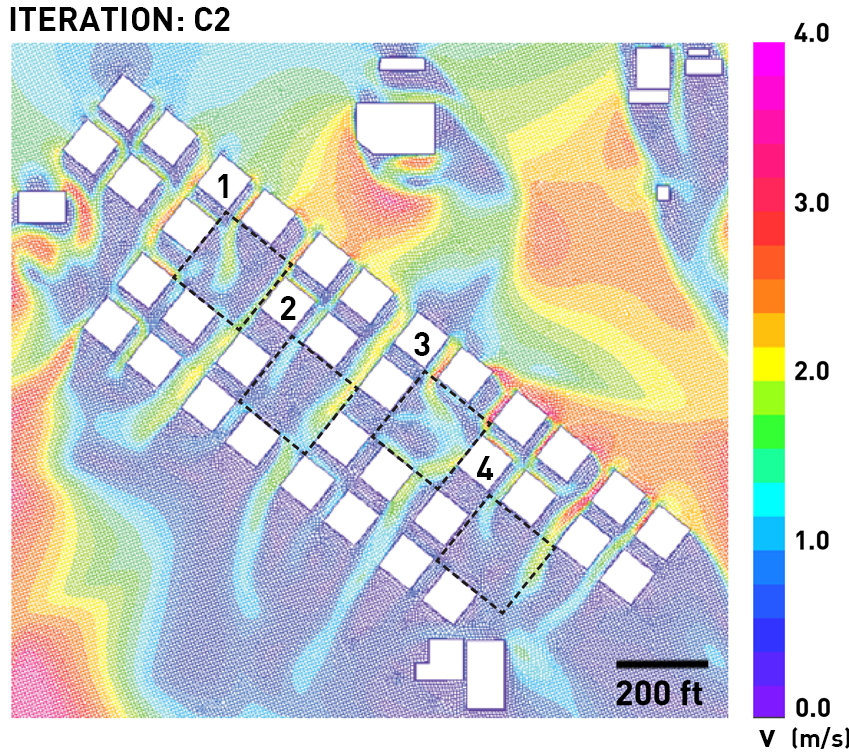
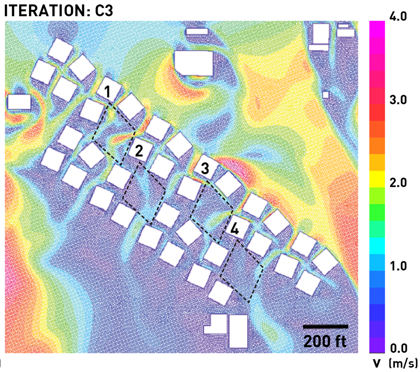
In order to account for the effect of wind speed on outdoor comfort, ANSYS Fluent was used to produce a second set of spatial maps. Portland TMY data determined the summer average wind speed and direction: 3.4m/s at NNW 112.5°, according to a true north-based azimuth. The simulation was ran in a x=2090.6m, y=776.6m and z=65.0m chamber with resolutions dx = dy = dz = 1.98m in space. From the CFD analyses, the wind speed for select points within each of the four plazas across all morphology iterations was chosen to determine the most relevant locations to the site in question. Since the CFD simulations were run for the center of gravity of an adult human (1.1m), the velocities were “back-converted” to meteorological height (10m) in order to calculate UTCI values (Jendritzky et al., 2007). After multiplying the simulation velocities by 1.5, the meteorological height wind speeds were then used to calculate UTCI values.
This methodology provides a computationally inexpensive and reliable approach in determining UTCI in relatively complex city grids, and showcases the importance of ancient vernacular urban morphologies in modern city development.
Data for the UTCI calculations and the Grasshopper components was sourced from: https://klimaat.ca/epw/
Manuscript:
Team:
Andrew Heid, Christopher Purpura, Theo Dimitrasopoulos.
Tools & methods:
Rhinoceros, Grasshopper, LadyBug suite, AutoCAD, V-Ray, CFD OpenStudio, ANSYS CFD.